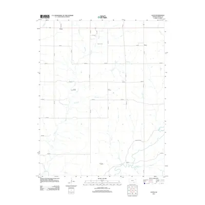
2012 Map of Eaton
USGS Topo · Published 2012About this map
The quiet settlement of Tisdale and the rural junction of Eaton anchor this Cowley County landscape, defined by a dense network of creek drainages and petroleum development. The terrain is deeply etched by waterways including Silver Cr, Grouse Cr, and Pebble Cr, which flow through a grid of section roads. This survey documents the persistent oil economy of the region, featuring the Cabin Valley Oil Field, Werner Oil Field, and the Maddox North Oil Field. Genealogy researchers will find the Prairie Ridge Cem situated centrally along the headwaters of Harper Cr. The map captures the interface between traditional agricultural parcels and the industrial footprint of local energy extraction, linked by a precise system of numbered routes such as 161st Rd and Grouse Creek Rd.
Find a feature on this map
33 named features on this map. Tap any name to fly to it.
Don’t see what you’re looking for? This feature index may not catch every label — zoom into the map to look around manually.
Map Details
Editions of this 2012 Eaton Map
This is the sole edition of this map. No revisions or reprints were ever made.
Other maps of this area

1889 · Burden
USGS Topo · 1:125,000

1955 · Wichita
USGS Topo · 1:250,000

1958 · Wichita
USGS Topo · 1:250,000

1962 · Dexter SW
USGS Topo · 1:24,000

1962 · Dexter
USGS Topo · 1:24,000

1962 · Cambridge
USGS Topo · 1:24,000

1964 · Burden
USGS Topo · 1:24,000
1964 · Maple City
USGS Topo · 1:24,000

1965 · Silverdale
USGS Topo · 1:24,000

1965 · Eaton
USGS Topo · 1:24,000