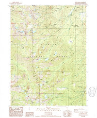
1986 Map of Eaton Peak
USGS Topo · Published 1986About this map
The Salmon Mountains define the high-elevation geography of this mid-1980s survey, a landscape where alpine lakes and narrow creeks dictate the movement of travelers. The Pacific Crest National Scenic Trail traverses the ridgelines, passing between prominent landmarks like Russian Peak and Grizzly Peak. This is a world of remote water sources, from the clustered Eaton Lakes to the isolated Big Blue Lake, which feed the headwaters of the South Fork Russian River.
Find a feature on this map
57 named features on this map. Tap any name to fly to it.
Don’t see what you’re looking for? This feature index may not catch every label — zoom into the map to look around manually.
Map Details
Editions of this 1986 Eaton Peak Map
2 editions found
Other maps of this area

1886 · Shasta
USGS Topo · 1:250,000

1894 · Shasta
USGS Topo · 1:250,000

1923 · Sawyers Bar
USGS Topo · 1:125,000

1931 · Etna
USGS Topo · 1:96,000

1934 · Etna
USGS Topo · 1:125,000

1948 · Weed
USGS Topo · 1:250,000

1950 · Weed
USGS Topo · 1:250,000

1955 · Cecilville
USGS Topo · 1:62,500

1955 · Sawyers Bar
USGS Topo · 1:62,500

1955 · Etna
USGS Topo · 1:62,500