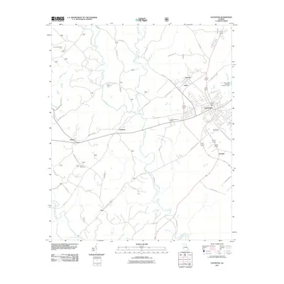
2011 Map of Eatonton
USGS Topo · Published 2011About this map
Eatonton serves as the central hub of this Putnam County landscape, where the Eatonton Post Office and Uncle Remus Golf Course mark the town's modern footprint. The surrounding countryside is defined by the winding course of the Little River and its numerous tributaries, including Glady Creek and Murder Creek. Settlement patterns reflect a mix of established rural communities like Linchburg and Willard, alongside specialized sites such as Mount Coilead Hunt Camp and Little River Hunt Camp.
Find a feature on this map
51 named features on this map. Tap any name to fly to it.
Don’t see what you’re looking for? This feature index may not catch every label — zoom into the map to look around manually.
Map Details
Editions of this 2011 Eatonton Map
This is the sole edition of this map. No revisions or reprints were ever made.
Other maps of this area

1953 · Athens
USGS Topo · 1:250,000

1958 · Athens
USGS Topo · 1:250,000

1959 · Athens
USGS Topo · 1:250,000

1963 · Athens
USGS Topo · 1:250,000

1964 · Stanfordville
USGS Topo · 1:24,000

1972 · Meda
USGS Topo · 1:24,000

1972 · Eatonton
USGS Topo · 1:24,000

1972 · Shady Dale
USGS Topo · 1:24,000
1972 · Smithboro
USGS Topo · 1:24,000

1972 · Harmony
USGS Topo · 1:24,000