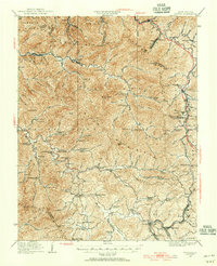
1929 Map of Eccles
USGS Topo · Published 1956About this map
The rugged Coal River Mountain and Kayford Mountain dominate this landscape during the late 1920s, a period when the deep valleys of West Virginia were densely dotted with small mountain schools and coal-adjacent settlements. The map shows a transition from the earlier era of the Virginia Turnpike to the modern engineering of the W. Va. Turnpike. This particular survey preserves a remarkable record of local education, mapping dozens of family-named schoolhouses such as McKinley School, Muddy Lynn School, and Dingess School. While industrial activity is implied by the proximity to the Coal River, the map also highlights vital social hubs like Matville Church and small post offices from Republic in the north to Eccles in the southeast. The intricate contour lines and mountain gaps, including Clear Fork Gap and Skinned Poplar Gap, reveal the difficult paths early residents traveled between the Sherman District and Trap Hill District.
Find a feature on this map
109 named features on this map. Tap any name to fly to it.
Don’t see what you’re looking for? This feature index may not catch every label — zoom into the map to look around manually.
Map Details
Editions of this 1929 Eccles Map
This is the sole edition of this map. No revisions or reprints were ever made.
Other maps of this area

1891 · Oceana
USGS Topo · 1:125,000

1891 · Raleigh
USGS Topo · 1:125,000

1893 · Oceana
USGS Topo · 1:125,000

1897 · Kanawha Falls
USGS Topo · 1:125,000

1897 · Raleigh
USGS Topo · 1:125,000

1898 · Oceana
USGS Topo · 1:125,000

1899 · Charleston
USGS Topo · 1:125,000

1900 · Kanawha Falls
USGS Topo · 1:125,000

1901 · Kanawha Falls
USGS Topo · 1:125,000

1902 · Raleigh
USGS Topo · 1:125,000