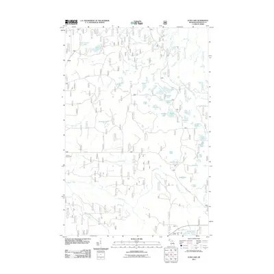
2011 Map of Echo Lake
USGS Topo · Published 2011About this map
Frost sits at the northwestern edge of this Houghton County landscape, an area characterized by an extensive network of small lakes and forest service roads. The geography is defined by numerous named water bodies, including the central Richard Lake and Still Lake, as well as the more remote Penegor Lake and Echo Lake in the north. The drainage system is complex, with Beaver Creek and Connors Creek threading between glacial depressions. The Connors Lookout Tower provides a significant landmark for the region, overlooking the dense topography and the many forest routes like FS RD 1300 and FS RD 1320. This area of the Ottawa National Forest shows a transition in land use focused on timber management and recreation, evidenced by the grid-like system of fire roads and the naming of small, isolated ponds and lakes like Markey Lake and Barchard Lake.
Find a feature on this map
43 named features on this map. Tap any name to fly to it.
Don’t see what you’re looking for? This feature index may not catch every label — zoom into the map to look around manually.
Map Details
Editions of this 2011 Echo Lake Map
This is the sole edition of this map. No revisions or reprints were ever made.
Other maps of this area

1895 · Perch Lake
USGS Topo · 1:62,500

1954 · Rousseau
USGS Topo · 1:62,500

1954 · Kenton
USGS Topo · 1:62,500

1954 · Perch Lake
USGS Topo · 1:62,500

1954 · Sidnaw
USGS Topo · 1:62,500

1958 · Iron River
USGS Topo · 1:250,000

1960 · Iron River
USGS Topo · 1:250,000

1961 · Iron River
USGS Topo · 1:250,000

1967 · Iron River
USGS Topo · 1:250,000
1982 · Sparrow Rapids
USGS Topo · 1:25,000