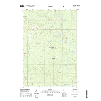
2019 Map of Echo Lake
USGS Topo · Published 2019About this map
The settlement of Frost sits on the western edge of this landscape in the Ottawa National Forest, where a dense network of forest roads and National Forest System Trails (NFST) provides access to a labyrinth of glacial water bodies. The terrain is defined by its immense collection of named lakes, including the central Echo Lake, Penegor Lake to the northwest, and the southern Booth Lake. This 2019 survey documents a contemporary wilderness management era where older routes like Old Nat For Dev Rd 1500 and 2210 Forest Rd coexist with modern recreation infrastructure such as Bessemer Snowmobile #8 (Snow). Small tributaries including Tradition Cr and Silver River drain these upland lakes, while the presence of features like Plantation Lakes suggests decades of forest management and timber history within Houghton County.
Find a feature on this map
118 named features on this map. Tap any name to fly to it.
Don’t see what you’re looking for? This feature index may not catch every label — zoom into the map to look around manually.
Map Details
Editions of this 2019 Echo Lake Map
This is the sole edition of this map. No revisions or reprints were ever made.
Other maps of this area

1895 · Perch Lake
USGS Topo · 1:62,500

1954 · Rousseau
USGS Topo · 1:62,500

1954 · Kenton
USGS Topo · 1:62,500

1954 · Perch Lake
USGS Topo · 1:62,500

1954 · Sidnaw
USGS Topo · 1:62,500

1958 · Iron River
USGS Topo · 1:250,000

1960 · Iron River
USGS Topo · 1:250,000

1961 · Iron River
USGS Topo · 1:250,000

1967 · Iron River
USGS Topo · 1:250,000
1982 · Sparrow Rapids
USGS Topo · 1:25,000