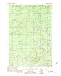
1982 Map of Echo Lake
USGS Topo · Published 1983About this map
The Ottawa National Forest dominates this landscape in southern Houghton County, characterized by a dense network of glacial lakes and wetlands managed under the Laird and Duncan townships. This 1980s era survey records a wilderness largely defined by its drainage systems, where Beaver Creek and Sidnaw Creek wind through the timberlands. The industrial backbone of the region is represented by the Escanaba and Lake Superior railroad line, which cuts a diagonal path across the northern and southeastern sections, linking remote points like Connors and Frost.
Find a feature on this map
36 named features on this map. Tap any name to fly to it.
Don’t see what you’re looking for? This feature index may not catch every label — zoom into the map to look around manually.
Map Details
Editions of this 1982 Echo Lake Map
This is the sole edition of this map. No revisions or reprints were ever made.
Other maps of this area

1895 · Perch Lake
USGS Topo · 1:62,500

1954 · Rousseau
USGS Topo · 1:62,500

1954 · Kenton
USGS Topo · 1:62,500

1954 · Perch Lake
USGS Topo · 1:62,500

1954 · Sidnaw
USGS Topo · 1:62,500

1958 · Iron River
USGS Topo · 1:250,000

1960 · Iron River
USGS Topo · 1:250,000

1961 · Iron River
USGS Topo · 1:250,000

1967 · Iron River
USGS Topo · 1:250,000
1982 · Sparrow Rapids
USGS Topo · 1:25,000