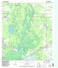
1994 Map of Echo
USGS Topo · Published 1996About this map
The Sabine River serves as a winding natural boundary between Texas and Louisiana, anchoring a dense network of bayous, islands, and wetlands within the Sabine Island State Wildlife Management Area. This 1994 revision captures a landscape defined by water and drainage, where prominent elevations like Niblett Bluff, Pruitt Bluff, and West Bluff rise above the surrounding swamp. To the east, the community of Toomey sits near the state line, while Echo and Ridgecrest occupy the western Texas side. The mapping of internal waterways such as Indian Bayou, Old River, and Gum Slough highlights the complex hydrology of the region. Scattered family-named cemeteries, including Lee Cem, Granger Cem, and Cormier Cem, provide specific points of interest for genealogists tracing local families in this river-border territory.
Find a feature on this map
53 named features on this map. Tap any name to fly to it.
Don’t see what you’re looking for? This feature index may not catch every label — zoom into the map to look around manually.
Map Details
Editions of this 1994 Echo Map
This is the sole edition of this map. No revisions or reprints were ever made.
Other maps of this area

1926 · Mauriceville
USGS Topo · 1:24,000

1932 · Orange
USGS Topo · 1:62,500

1943 · Orangefield
USGS Topo · 1:24,000

1943 · Mauriceville
USGS Topo · 1:24,000

1946 · Phoenix Lake
USGS Topo · 1:31,680

1947 · Starks
USGS Topo · 1:31,680

1947 · Vinton
USGS Topo · 1:31,680

1947 · Toomey
USGS Topo · 1:31,680

1947 · Lunita
USGS Topo · 1:31,680
1949 · Cameron Farms
USGS Topo · 1:31,680