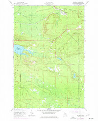
1951 Map of Eckerman
USGS Topo · Published 1977About this map
Eckerman and Eckerman Corner serve as the primary human hubs within this heavily forested expanse of the Hiawatha National Forest. The landscape is defined by the winding course of the Tahquamenon River and its East Branch, which cut through the northern timberlands near a state Fish Hatchery. The industrial and transportation history of the Upper Peninsula is evident in the path of the Duluth South Shore and Atlantic railroad and several stretches of Old Railroad Grade that suggest earlier logging routes. Recreational use and seasonal residency are marked by isolated landmarks such as La Rock Cabins, the Hendrie River Camp, and the Petersburg Club. To the west, the sizable Hulbert Lake and Mud Lake anchor a wetland system that drains through numerous family-named creeks including Grants Creek and Riley Creek.
Find a feature on this map
31 named features on this map. Tap any name to fly to it.
Don’t see what you’re looking for? This feature index may not catch every label — zoom into the map to look around manually.
Map Details
Editions of this 1951 Eckerman Map
2 editions found
Other maps of this area

1931 · Epoufette NE
USGS Topo · 1:31,680

1931 · Epoufette NW
USGS Topo · 1:31,680

1941 · Strongs
USGS Topo · 1:63,360

1951 · Strongs
USGS Topo · 1:24,000

1951 · McNearney Lake
USGS Topo · 1:24,000

1951 · Piatt Lake
USGS Topo · 1:24,000

1951 · Big Beaver Creek
USGS Topo · 1:24,000

1951 · Hulbert
USGS Topo · 1:24,000

1951 · Eckerman
USGS Topo · 1:24,000

1951 · Strongs
USGS Topo · 1:62,500