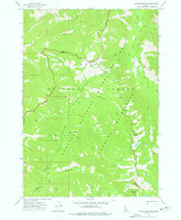
1972 Map of Edaho Mountain
USGS Topo · Published 1976About this map
Edaho Mtn serves as a prominent landmark at the southern edge of this high-elevation landscape where the Boise and Elmore county lines meet. The terrain is defined by its extensive network of watercourses, including the South Fork Payette River and the headwaters of the North Fork Boise River. In the early 1970s, this area was characterized by its limited human footprint, primarily evidenced by a small X Prospect near Picket Mtn and the family-named Taylor Spring. Large expanses of the Sawtooth Wilderness and Sawtooth National Forest dominate the quadrangle, with Big Meadows providing a break in the forested slopes. Travel through this area during this era relied heavily on specialized routes such as the Pack Trail and Jeep Pack Trail, reflecting the isolation of the Bugle Mtn and McLeod Creek drainages.
Find a feature on this map
30 named features on this map. Tap any name to fly to it.
Don’t see what you’re looking for? This feature index may not catch every label — zoom into the map to look around manually.
Map Details
Editions of this 1972 Edaho Mountain Map
2 editions found
Other maps of this area

1891 · Bear Valley
USGS Topo · 1:125,000

1893 · Bear Valley
USGS Topo · 1:125,000

1894 · Rocky Bar
USGS Topo · 1:125,000

1955 · Hailey
USGS Topo · 1:250,000

1957 · Challis
USGS Topo · 1:250,000

1959 · Hailey
USGS Topo · 1:250,000

1960 · Challis
USGS Topo · 1:250,000

1962 · Hailey
USGS Topo · 1:250,000

1963 · Challis
USGS Topo · 1:250,000
1972 · Tyee Mountain
USGS Topo · 1:24,000