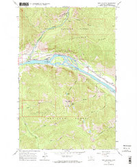
1964 Map of Eddy Mountain
USGS Topo · Published 1967About this map
The Thompson River joins the Clark Fork in this mid-century look at the Sanders County mountain country. Industrial activity is centered on the northern reaches of the Lolo National Forest, where the Copper King Mine, Raven Mine, and Silver King Mine sit high above Buckeye Canyon. This rugged terrain is defined by the Kookoosint Ridge and the Eddy Mountain summit, which is topped with a Lookout. The rail-and-river corridor below is dominated by the Northern Pacific railroad, which follows the river's bend past the small settlement of Eddy. The landscape reflects a legacy of extraction and high-altitude monitoring, with narrow drainages like Outlaw Creek and Quartz Creek carving through the steep slopes toward the valley floor.
Find a feature on this map
28 named features on this map. Tap any name to fly to it.
Don’t see what you’re looking for? This feature index may not catch every label — zoom into the map to look around manually.
Map Details
Editions of this 1964 Eddy Mountain Map
2 editions found

Other maps of this area

1918 · St Regis
USGS Topo · 1:125,000

1919 · St. Regis
USGS Topo · 1:125,000

1937 · Thompson Falls
USGS Topo · 1:125,000

1937 · Thompson Falls
USGS Topo · 1:62,500

1956 · St Regis
USGS Topo · 1:62,500

1956 · Wallace
USGS Topo · 1:250,000

1957 · Thompson Falls
USGS Topo · 1:62,500

1957 · Haugan
USGS Topo · 1:62,500

1960 · Wallace
USGS Topo · 1:250,000

1964 · Calico Creek
USGS Topo · 1:24,000