
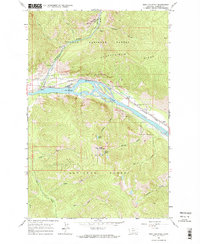
1964 Map of Eddy Mountain
USGS Topo · Published 1967About this map
Lolo National Forest dominates this mountain landscape, where the Thompson River meets the Clark Fork in a narrow valley corridor. The mid-1960s terrain shows a landscape shaped by both extraction and infrastructure, with the Northern Pacific railroad skirting the riverbanks through small settlements like Snider and Eddy.
Find a feature on this map
30 named features on this map. Tap any name to fly to it.
Don’t see what you’re looking for? This feature index may not catch every label — zoom into the map to look around manually.
Map Details
Editions of this 1964 Eddy Mountain Map
2 editions found
Other maps of this area

1918 · St Regis
USGS Topo · 1:125,000

1919 · St. Regis
USGS Topo · 1:125,000

1937 · Thompson Falls
USGS Topo · 1:125,000

1937 · Thompson Falls
USGS Topo · 1:62,500

1956 · St Regis
USGS Topo · 1:62,500

1956 · Wallace
USGS Topo · 1:250,000

1957 · Thompson Falls
USGS Topo · 1:62,500

1957 · Haugan
USGS Topo · 1:62,500

1960 · Wallace
USGS Topo · 1:250,000

1964 · Calico Creek
USGS Topo · 1:24,000