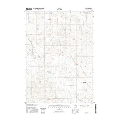
2015 Map of Eden
USGS Topo · Published 2015About this map
The Sheboygan River and Milwaukee River both carve through this segment of Fond du Lac County, defining a landscape of glacial hydrology and early Wisconsin settlement. The village of Eden sits at the western edge of the sheet, while the rural community of Waucousta anchors the southeast, surrounded by extensive wetlands like McCullough Marsh. This 2015 survey reveals a dense concentration of local heritage sites, particularly nineteenth-century burial grounds including Odekirk Cem, Gudex Cem, and Saint Marys Cem, which serve as vital landmarks for genealogists tracing the area's ancestral roots. Aviation history is represented by the Dinnerbell Airport, situated among the rolling fields between the township lines. The map's grid of county roads, such as Co RD B and Co RD W, links these scattered hamlets, while features like Twin Lakes provide focal points for local recreation and drainage.
Find a feature on this map
78 named features on this map. Tap any name to fly to it.
Don’t see what you’re looking for? This feature index may not catch every label — zoom into the map to look around manually.
Map Details
Editions of this 2015 Eden Map
This is the sole edition of this map. No revisions or reprints were ever made.
Other maps of this area

1910 · Fond du Lac
USGS Topo · 1:62,500

1954 · Kiel
USGS Topo · 1:62,500

1955 · Campbellsport
USGS Topo · 1:62,500

1955 · Kewaskum
USGS Topo · 1:62,500

1955 · Fond Du Lac
USGS Topo · 1:62,500

1955 · Fond Du Lac
USGS Topo · 1:24,000

1957 · Madison
USGS Topo · 1:250,000

1960 · Madison
USGS Topo · 1:250,000

1974 · St. Cloud
USGS Topo · 1:24,000
1974 · Dundee
USGS Topo · 1:24,000