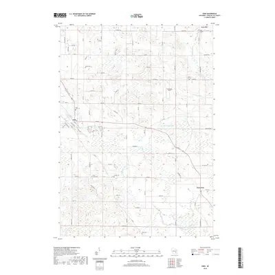
2018 Map of Eden
USGS Topo · Published 2018About this map
Eden and Dotyville anchor the northern reaches of this landscape, where the upper branches of the Sheboygan River and the Milwaukee River begin their drainage of Fond du Lac County. The terrain is defined by its glacial history, featuring the expansive McCullough Marsh and the small Twin Lakes. This rural community is notable for its numerous burial grounds, including Saint Michael Cem, Empire Cem, and Odekirk Cem, which provide significant points of reference for genealogists tracking local family histories in Ashford and the surrounding townships. A mix of legacy roads like Mushroom Rd and Fond du Lac Ave connect these small settlements. In the center of the sheet, the private Dinnerbell Airport serves as a modern landmark amongst traditional farmsteads and the meandering river systems that dictate the layout of the local transport network.
Find a feature on this map
53 named features on this map. Tap any name to fly to it.
Don’t see what you’re looking for? This feature index may not catch every label — zoom into the map to look around manually.
Map Details
Editions of this 2018 Eden Map
This is the sole edition of this map. No revisions or reprints were ever made.
Other maps of this area

1910 · Fond du Lac
USGS Topo · 1:62,500

1954 · Kiel
USGS Topo · 1:62,500

1955 · Campbellsport
USGS Topo · 1:62,500

1955 · Kewaskum
USGS Topo · 1:62,500

1955 · Fond Du Lac
USGS Topo · 1:62,500

1955 · Fond Du Lac
USGS Topo · 1:24,000

1957 · Madison
USGS Topo · 1:250,000

1960 · Madison
USGS Topo · 1:250,000

1974 · St. Cloud
USGS Topo · 1:24,000
1974 · Dundee
USGS Topo · 1:24,000