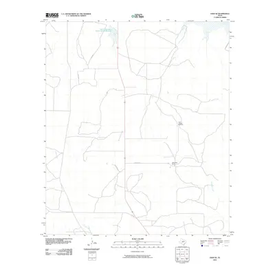
2010 Map of Eden SE
USGS Topo · Published 2010About this map
Whitehead Ranch stands as a primary landmark in this ranching landscape of Menard County, where the network of local roads and water sources reveals the area's rural character. The terrain is defined by seasonal watercourses such as South Brady Creek, West Scalp Creek, and Celery Creek, which drain toward larger basins. Land management is visible through the Soil Conservation Service Site 26 Reservoir in the northern portion of the quadrangle, reflecting regional efforts in water conservation and erosion control. Isolated infrastructure like the Plum Thicket Windmill highlights the reliance on groundwater for livestock in this semi-arid part of Texas. Transportation in the early 21st century follows a sparse grid of ranch-to-market and county roads, including Fm 1223 and the specialized routes Whitehead E and Whitehead W serving the local estates.
Find a feature on this map
12 named features on this map. Tap any name to fly to it.
Don’t see what you’re looking for? This feature index may not catch every label — zoom into the map to look around manually.
Map Details
Editions of this 2010 Eden SE Map
This is the sole edition of this map. No revisions or reprints were ever made.
Other maps of this area

1892 · Eden
USGS Topo · 1:125,000

1896 · Eden
USGS Topo · 1:125,000

1954 · Brownwood
USGS Topo · 1:250,000

1954 · Llano
USGS Topo · 1:250,000

1955 · Llano
USGS Topo · 1:250,000

1956 · Llano
USGS Topo · 1:250,000
1970 · Live Oak
USGS Topo · 1:24,000

1970 · Callan
USGS Topo · 1:24,000

1970 · Clear Creek Lake
USGS Topo · 1:24,000
1970 · Eden
USGS Topo · 1:24,000