
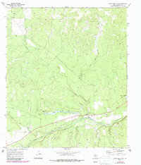
1970 Map of Clear Creek Lake
USGS Topo · Published 1973About this map
The San Saba River cuts through the southern reaches of this West Texas landscape, where the confluence of numerous drainages like Bois D'Arc Creek and Fields Creek create a complex system of draws and ridges. Local transit and water access in the early 1970s are marked by the Beyer Crossing on the river and the presence of Clear Creek Lake, which collects the flow of Clear Creek and Silver Mine Creek. This survey captures the region during a period of active resource extraction, evidenced by a designated Oil Field to the north and various Prospects and gravel pits scattered across the terrain.
Find a feature on this map
24 named features on this map. Tap any name to fly to it.
Don’t see what you’re looking for? This feature index may not catch every label — zoom into the map to look around manually.
Map Details
Editions of this 1970 Clear Creek Lake Map
2 editions found
Other maps of this area

1892 · San Angelo
USGS Topo · 1:125,000

1892 · Eden
USGS Topo · 1:125,000

1893 · Fort McKavett
USGS Topo · 1:125,000

1896 · Eden
USGS Topo · 1:125,000

1954 · Brownwood
USGS Topo · 1:250,000

1954 · Llano
USGS Topo · 1:250,000

1954 · Sonora
USGS Topo · 1:250,000

1954 · San Angelo
USGS Topo · 1:250,000

1955 · Llano
USGS Topo · 1:250,000

1956 · Llano
USGS Topo · 1:250,000