
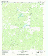
1970 Map of Callan
USGS Topo · Published 1973About this map
Callan sits at the intersection of rural ranching life and rail transport along the Atchison Topeka and Santa Fe railroad line. Located on the boundary of Concho and Menard counties, this landscape is defined by its intermittent watercourses, including Reubes Creek, Fountain Creek, and Scalp Creek, which carve through the Edwards Plateau terrain. The settlement is centered around a small collection of structures and a Gravel Pit, reflecting the area's modest industrial activity and transit-based economy in the early 1970s.
Find a feature on this map
12 named features on this map. Tap any name to fly to it.
Don’t see what you’re looking for? This feature index may not catch every label — zoom into the map to look around manually.
Map Details
Editions of this 1970 Callan Map
2 editions found
Other maps of this area

1892 · Eden
USGS Topo · 1:125,000

1896 · Eden
USGS Topo · 1:125,000

1954 · Brownwood
USGS Topo · 1:250,000

1954 · Llano
USGS Topo · 1:250,000

1955 · Llano
USGS Topo · 1:250,000

1956 · Llano
USGS Topo · 1:250,000

1960 · Melvin
USGS Topo · 1:24,000
1970 · Needle Creek
USGS Topo · 1:24,000
1970 · Eden
USGS Topo · 1:24,000
1970 · Pasche
USGS Topo · 1:24,000