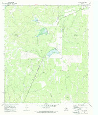
1970 Map of Callan
USGS Topo · Published 1973About this map
The Atchison Topeka and Santa Fe railroad corridor cuts a diagonal path through the heart of the Concho and Menard county line, serving the small community of Callan. This landscape, documented just before the 1970s, is defined by an extensive network of seasonal watercourses including Reubes Creek, Fountain Creek, and the multi-branched Scalp Creek. The presence of several spillways and riser structures along these drainages indicates a controlled water management system designed to mitigate the effects of flash flooding in the West Texas draws. Genealogists will find the Loveless Cem in the north and the settlement of Wilhelm to the south. The rural infrastructure of the era is further highlighted by a private Landing Strip and local gravel pits, reflecting the modest industrial and transportation needs of this ranching region.
Find a feature on this map
19 named features on this map. Tap any name to fly to it.
Don’t see what you’re looking for? This feature index may not catch every label — zoom into the map to look around manually.
Map Details
Editions of this 1970 Callan Map
2 editions found
Other maps of this area

1892 · Eden
USGS Topo · 1:125,000

1896 · Eden
USGS Topo · 1:125,000

1954 · Brownwood
USGS Topo · 1:250,000

1954 · Llano
USGS Topo · 1:250,000

1955 · Llano
USGS Topo · 1:250,000

1956 · Llano
USGS Topo · 1:250,000

1960 · Melvin
USGS Topo · 1:24,000

1970 · Callan
USGS Topo · 1:24,000
1970 · Needle Creek
USGS Topo · 1:24,000
1970 · Eden
USGS Topo · 1:24,000