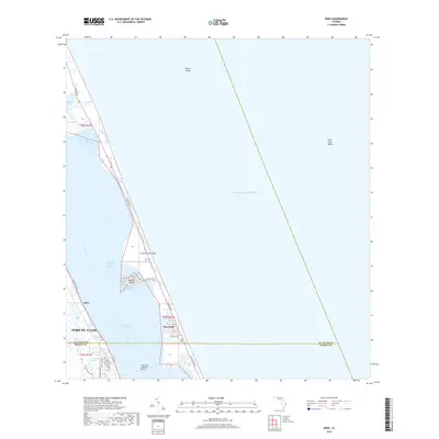
2018 Map of Eden
USGS Topo · Published 2018About this map
Hutchinson Island separates the Atlantic coast from the Indian River Lagoon in this detailed survey of the Treasure Coast. The coastal barrier landscape is defined by the thin stretch of S Ocean Dr and NE Ocean Blvd, connecting residential developments like Nettles Island to the mainland. On the western shore of the Indian River, the community of Eden and the expanding borders of Port St. Lucie sit along the Co Rd 707 corridor. Transport between these environments is anchored by The Frank A Wacha Bridge, which spans the Intracostal Waterway. The map captures a transition point where established settlements meet protected waters and offshore features like Pierce Shoal and Saint Lucie Shoal, illustrating the modern balance of Florida's waterfront infrastructure and nautical hazards.
Find a feature on this map
29 named features on this map. Tap any name to fly to it.
Don’t see what you’re looking for? This feature index may not catch every label — zoom into the map to look around manually.
Map Details
Editions of this 2018 Eden Map
This is the sole edition of this map. No revisions or reprints were ever made.
Other maps of this area

1948 · Palm City
USGS Topo · 1:24,000

1948 · Ankona
USGS Topo · 1:24,000

1948 · St. Lucie Inlet
USGS Topo · 1:24,000

1948 · Eden
USGS Topo · 1:24,000

1949 · Fort Pierce
USGS Topo · 1:24,000

1950 · St. Lucie Inlet
USGS Topo · 1:24,000

1950 · Ankona
USGS Topo · 1:24,000

1950 · Fort Pierce
USGS Topo · 1:24,000

1950 · Palm City
USGS Topo · 1:24,000
1950 · Eden
USGS Topo · 1:24,000