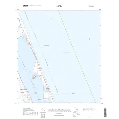
2021 Map of Eden
USGS Topo · Published 2021About this map
The barrier islands and brackish reaches of the Indian River Lagoon define this 2021 study of the Florida coastline near the boundary of St Lucie and Martin Counties. On the mainland, the established community of Eden and the expanding footprint of Port St. Lucie front the Indian River, while the Intracoastal Waterway provides a sheltered transit corridor between the shore and the Atlantic. Across the water, Hutchinson Island and the residential grid of Nettles Island highlight the intense focus on waterfront living and recreation. The Frank A Wacha Bridge serves as the primary link between these coastal communities. For those navigating the shoals, the map identifies maritime hazards such as Pierce Shoal and Saint Lucie Shoal in the open Atlantic Ocean. Natural preserves and recreation are also evident, from the Ocean Bay Preserve Trl to the long-distance Florida Circumnavigational Paddling Trl threading through the lagoon.
Find a feature on this map
38 named features on this map. Tap any name to fly to it.
Don’t see what you’re looking for? This feature index may not catch every label — zoom into the map to look around manually.
Map Details
Editions of this 2021 Eden Map
This is the sole edition of this map. No revisions or reprints were ever made.
Other maps of this area

1948 · Palm City
USGS Topo · 1:24,000

1948 · Ankona
USGS Topo · 1:24,000

1948 · St. Lucie Inlet
USGS Topo · 1:24,000

1948 · Eden
USGS Topo · 1:24,000

1949 · Fort Pierce
USGS Topo · 1:24,000

1950 · St. Lucie Inlet
USGS Topo · 1:24,000

1950 · Ankona
USGS Topo · 1:24,000

1950 · Fort Pierce
USGS Topo · 1:24,000

1950 · Palm City
USGS Topo · 1:24,000
1950 · Eden
USGS Topo · 1:24,000