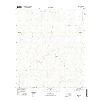
2016 Map of Eden SW
USGS Topo · Published 2016About this map
Negro Gap and the surrounding drainage basins of the San Saba River watershed define this rural landscape on the border of Concho and Menard Counties. This mid-2010s survey reveals a territory dominated by seasonal watercourses and conservation efforts, most notably the Soil Conservation Service Site 29 Reservoir in the north. The area is characterized by a sparse network of ranch roads and family-named thoroughfares like Wilhelm Ln and Waddell Ln that navigate the undulating terrain. A distinct geographic feature, the Arroyo de Juan Lorenzo, cuts through the central hills, feeding into a system of creeks including Live Oak Cr, Fitzgerald Cr, and Celery Cr. This map is particularly useful for understanding the modern hydrologic management and property divisions in this portion of the Edwards Plateau.
Find a feature on this map
17 named features on this map. Tap any name to fly to it.
Don’t see what you’re looking for? This feature index may not catch every label — zoom into the map to look around manually.
Map Details
Editions of this 2016 Eden SW Map
This is the sole edition of this map. No revisions or reprints were ever made.
Other maps of this area
1892 · San Angelo
USGS Topo · 1:125,000
1892 · Eden
USGS Topo · 1:125,000
1893 · Fort McKavett
USGS Topo · 1:125,000
1896 · Eden
USGS Topo · 1:125,000
1954 · Brownwood
USGS Topo · 1:250,000
1954 · Llano
USGS Topo · 1:250,000

1954 · Sonora
USGS Topo · 1:250,000

1954 · San Angelo
USGS Topo · 1:250,000
1955 · Llano
USGS Topo · 1:250,000
1956 · Llano
USGS Topo · 1:250,000