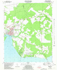
1981 Map of Edenton
USGS Topo · Published 1981About this map
The colonial port city of Edenton stands at the head of Edenton Bay, where the confluence of Pembroke Cr and Queen Anne Creek meets the northern reaches of the Albemarle Sound. This 1980s-era map reveals the town's expansion along the waterfront and inland towards the Edenton Municipal Airport. The landscape is a mix of dense municipal planning and rural reaches, with the Norfolk Southern railroad cutting across the northern territory toward Yeopim. Significant local landmarks like Walker Sch and Holmes High Sch anchor the residential sections, while the shoreline is marked by the Seawall and residential developments like Cape Colony. The inclusion of numerous historical sites, such as Vine Oak Cem and St Luke Ch, provides a clear view of the community's established footprint during a period of modern infrastructure growth, including the Filtration Plant Water Tank and Sewage Disposal systems.
Find a feature on this map
39 named features on this map. Tap any name to fly to it.
Don’t see what you’re looking for? This feature index may not catch every label — zoom into the map to look around manually.
Map Details
Editions of this 1981 Edenton Map
2 editions found
Other maps of this area

1904 · Edenton
USGS Topo · 1:62,500

1906 · Hertford
USGS Topo · 1:62,500

1940 · Hertford
USGS Topo · 1:62,500

1942 · Edenton
USGS Topo · 1:62,500

1943 · Columbia
USGS Topo · 1:125,000

1943 · Plymouth
USGS Topo · 1:125,000

1943 · Edenton
USGS Topo · 1:62,500

1953 · Norfolk
USGS Topo · 1:250,000

1953 · Rocky Mount
USGS Topo · 1:250,000

1954 · Rocky Mount
USGS Topo · 1:250,000