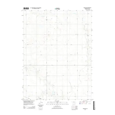
2014 Map of Edgar NW
USGS Topo · Published 2014About this map
Edgar anchors the southern edge of this survey, where the grid of 8th St and N D St meets the rural agricultural expanse of Clay County. The landscape is defined by the headwaters of the Sandy Creek system, with Big Sandy Cr and Little Sandy Cr cutting through a strictly partitioned section-line road network. This alignment highlights the persistent Jeffersonian grid that dictates Nebraska's agrarian geography, as seen in the precise spacing of Road 14 and Road S. For local historians, the map preserves the exact locations of Evergreen Cem in the north and Chapel Grove Cem to the east, providing fixed points for genealogical research in this sparsely settled region. The transit corridor of Ne-74 serves as the primary east-west artery, connecting the isolated farmsteads and rural properties that characterize this High Plains terrain.
Find a feature on this map
26 named features on this map. Tap any name to fly to it.
Don’t see what you’re looking for? This feature index may not catch every label — zoom into the map to look around manually.
Map Details
Editions of this 2014 Edgar NW Map
This is the sole edition of this map. No revisions or reprints were ever made.
Other maps of this area
1898 · York
USGS Topo · 1:125,000
1898 · Superior
USGS Topo · 1:125,000
1898 · Hebron
USGS Topo · 1:125,000
1898 · Grand Island
USGS Topo · 1:125,000
1899 · York
USGS Topo · 1:125,000
1955 · Lincoln
USGS Topo · 1:250,000
1955 · Grand Island
USGS Topo · 1:250,000
1957 · Lincoln
USGS Topo · 1:250,000
1957 · Grand Island
USGS Topo · 1:250,000
1958 · Grand Island
USGS Topo · 1:250,000