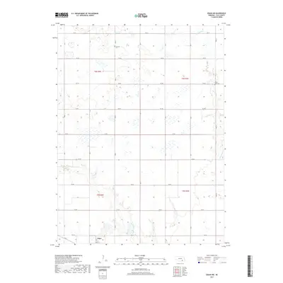
2017 Map of Edgar NW
USGS Topo · Published 2017About this map
Edgar sits at the southern edge of this Clay County landscape, where the local road network grid, including 8th ST, connects the town to the surrounding agricultural prairie. The terrain is defined by the drainage patterns of Little Sandy Cr in the north and east, and Big Sandy Cr meandering through the southern sections. These watercourses provide a natural counterpoint to the rigid sections of the Public Land Survey System, which are meticulously bounded by roads such as RD 311 and RD Q. Genealogists and local historians will find significant value in the documentation of local burial sites, specifically Evergreen Cem located near the center of the sheet and Chapel Grove Cem situated along the eastern boundary near the creek. The map illustrates the late 20th-century rural infrastructure of the Nebraska plains, where farm-to-market roads like RD 303 and RD 52 facilitate the movement of goods and people.
Find a feature on this map
27 named features on this map. Tap any name to fly to it.
Don’t see what you’re looking for? This feature index may not catch every label — zoom into the map to look around manually.
Map Details
Editions of this 2017 Edgar NW Map
This is the sole edition of this map. No revisions or reprints were ever made.
Other maps of this area
1898 · York
USGS Topo · 1:125,000
1898 · Superior
USGS Topo · 1:125,000
1898 · Hebron
USGS Topo · 1:125,000
1898 · Grand Island
USGS Topo · 1:125,000
1899 · York
USGS Topo · 1:125,000
1955 · Lincoln
USGS Topo · 1:250,000
1955 · Grand Island
USGS Topo · 1:250,000
1957 · Lincoln
USGS Topo · 1:250,000
1957 · Grand Island
USGS Topo · 1:250,000
1958 · Grand Island
USGS Topo · 1:250,000