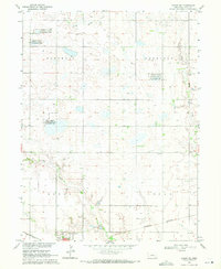
1969 Map of Edgar NW
USGS Topo · Published 1972About this map
Alberding Lagoon National Wildlife Management Area and several other dedicated conservation zones dominate the agricultural landscape of Clay County in this late 1960s survey. The map details a region defined by its vital water resources and drainage patterns, specifically Little Sandy Creek and Sandy Creek, which meander through township sections once divided into Marshall, Sheridan, Edgar, and Logan precincts. The town of Edgar sits at the southwestern edge of the quadrangle, serving as a hub where the Union Pacific and Burlington Northern railroads converge.
Find a feature on this map
17 named features on this map. Tap any name to fly to it.
Don’t see what you’re looking for? This feature index may not catch every label — zoom into the map to look around manually.
Map Details
Editions of this 1969 Edgar NW Map
This is the sole edition of this map. No revisions or reprints were ever made.
Other maps of this area

1898 · York
USGS Topo · 1:125,000

1898 · Superior
USGS Topo · 1:125,000

1898 · Hebron
USGS Topo · 1:125,000

1898 · Grand Island
USGS Topo · 1:125,000

1899 · York
USGS Topo · 1:125,000

1955 · Lincoln
USGS Topo · 1:250,000

1955 · Grand Island
USGS Topo · 1:250,000

1957 · Lincoln
USGS Topo · 1:250,000

1957 · Grand Island
USGS Topo · 1:250,000

1958 · Grand Island
USGS Topo · 1:250,000