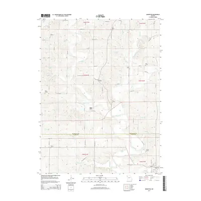
2014 Map of Edgerton
USGS Topo · Published 2014About this map
The Platte River snakes through this agricultural corridor along the border of Buchanan and Platte counties, creating a landscape defined by seasonal waterways and small impoundments. The settlement of Edgerton sits at the southern edge of the sheet, serving as a focal point for the surrounding rural road network. For genealogists, the map is remarkably dense with burial sites that trace the region's 19th-century settlement patterns, including the Union Mill Cemetery, Brinton Cemetery, and Number 6 Cemetery. These sites, often located on higher ground overlooking tributaries like Castile Cr and Malden Cr, reveal the placement of early family homesteads and vanished rural congregations. Topographically, the area is marked by numerous small lakes such as Grant Lake, Cantrell Lake, and Gamble Lake, which alongside the river bottomlands, illustrate the hydrology of northwestern Missouri's dissected till plains.
Find a feature on this map
53 named features on this map. Tap any name to fly to it.
Don’t see what you’re looking for? This feature index may not catch every label — zoom into the map to look around manually.
Map Details
Editions of this 2014 Edgerton Map
This is the sole edition of this map. No revisions or reprints were ever made.
Other maps of this area

1890 · Kansas City
USGS Topo · 1:125,000

1894 · Kansas City
USGS Topo · 1:125,000

1910 · Leavenworth
USGS Topo · 1:62,500

1914 · Smithville
USGS Topo · 1:62,500

1925 · Gower
USGS Topo · 1:62,500

1927 · Dearborn
USGS Topo · 1:62,500

1948 · Leavenworth
USGS Topo · 1:62,500

1950 · Kansas City
USGS Topo · 1:250,000
1950 · Smithville
USGS Topo · 1:62,500
1951 · Smithville
USGS Topo · 1:24,000