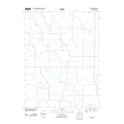
2012 Map of Edina SE
USGS Topo · Published 2012About this map
The South Fabius River and Little Fabius River snake through this section of Knox County, defining a landscape shaped by intricate drainage systems and agricultural boundaries. Near the center of the map, the small settlement of Bee Ridge sits on a high point between river bends, serving as a quiet focal point for the surrounding rural road network. The terrain is characterized by numerous seasonal and permanent waterways, including Troublesome Creek, Cottey Creek, and several stretches of Long Branch that feed into the larger river systems.
Find a feature on this map
54 named features on this map. Tap any name to fly to it.
Don’t see what you’re looking for? This feature index may not catch every label — zoom into the map to look around manually.
Map Details
Editions of this 2012 Edina SE Map
This is the sole edition of this map. No revisions or reprints were ever made.
Other maps of this area

1903 · Kahoka
USGS Topo · 1:125,000

1903 · Palmyra
USGS Topo · 1:125,000

1903 · Edina
USGS Topo · 1:125,000

1948 · Quincy
USGS Topo · 1:250,000

1950 · La Belle
USGS Topo · 1:24,000

1951 · La Belle
USGS Topo · 1:24,000
1951 · Deer Ridge
USGS Topo · 1:24,000

1953 · Moberly
USGS Topo · 1:250,000

1954 · Centerville
USGS Topo · 1:250,000

1954 · Moberly
USGS Topo · 1:250,000