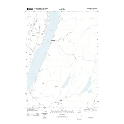
2013 Map of Edinburg
USGS Topo · Published 2013About this map
Great Sacandaga Lake dominates this landscape, reflecting a massive reservoir system that reshaped the valley's settlement patterns. The historic Copeland Covered Bridge and the Sacandaga Reservoir Bridge serve as primary crossings near Edinburg and Batchellerville, connecting localized road networks along the western shore. The map details a transition from the lakeside communities to the interior highlands, where features like Bald Bluff and Maxon Ridge rise above the surrounding drainages. Genealogy researchers will find several localized burial grounds, including Partridge Cem and Brooks Cem, while the southern reaches of the quadrangle show the smaller hamlets of Fayville and Glenwild situated along the winding courses of Fayville Cr and Hans Cr. The presence of the Circle K Ranch Airport and various small water bodies like Shew Pond and Albia Pond highlight the mixed recreational and agricultural character of the Fulton County region.
Find a feature on this map
73 named features on this map. Tap any name to fly to it.
Don’t see what you’re looking for? This feature index may not catch every label — zoom into the map to look around manually.
Map Details
Editions of this 2013 Edinburg Map
This is the sole edition of this map. No revisions or reprints were ever made.
Other maps of this area

1899 · Broadalbin
USGS Topo · 1:62,500

1902 · Broadalbin
USGS Topo · 1:62,500

1902 · Saratoga
USGS Topo · 1:62,500

1903 · Luzerne
USGS Topo · 1:62,500

1910 · Stony Creek
USGS Topo · 1:62,500

1935 · Middle Grove
USGS Topo · 1:24,000

1942 · Saratoga
USGS Topo · 1:62,500

1945 · Edinburg
USGS Topo · 1:24,000
1945 · Galway
USGS Topo · 1:24,000

1945 · Northville
USGS Topo · 1:24,000