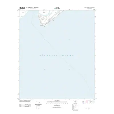
2011 Map of Edisto Beach
USGS Topo · Published 2011About this map
Edisto Beach occupies the narrow coastal shelf of Edisto Island, bordered by the expansive Atlantic Ocean and the winding channels of the South Carolina Lowcountry. This coastal landscape is defined by the convergence of the South Edisto River and the South Edisto Inlet, which separate the mainland reaches from barrier features like Pine Island and the prominent Bay Point. The residential street grid of the beach community is clearly delineated, showing established corridors such as Battery Park Rd and Fairway Dr tucked behind the tidal marshes of Big Bay Creek and Scott Creek. Because the majority of this survey covers the open waters of the Atlantic, it serves as a precise record of the shoreline and inlet morphology at the beginning of the 2010s.
Find a feature on this map
13 named features on this map. Tap any name to fly to it.
Don’t see what you’re looking for? This feature index may not catch every label — zoom into the map to look around manually.
Map Details
Editions of this 2011 Edisto Beach Map
This is the sole edition of this map. No revisions or reprints were ever made.
Other maps of this area

1919 · Edisto Island
USGS Topo · 1:62,500

1919 · Wadmelaw Island
USGS Topo · 1:62,500

1920 · St. Helena Sound
USGS Topo · 1:62,500

1943 · Edisto Island
USGS Topo · 1:62,500

1944 · Wadmelaw Island
USGS Topo · 1:62,500

1947 · Savannah
USGS Topo · 1:250,000

1948 · St. Helena Sound
USGS Topo · 1:62,500

1948 · Savannah
USGS Topo · 1:250,000
1956 · Edisto Beach
USGS Topo · 1:24,000
1956 · St. Helena Sound
USGS Topo · 1:24,000