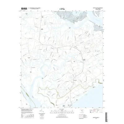
2017 Map of Edisto Island
USGS Topo · Published 2017About this map
The Intracoastal Waterway and the Dawho River define the northern reaches of this coastal landscape, where the sea meets a complex network of creeks and marshlands. This modern survey illustrates the enduring settlement patterns of Edisto Island, from the central community of Freedman to the more secluded residential areas along Edisto Beach. The map reveals the intricate geography of the Sea Islands, where larger landmasses like Bailey Island and Jehossee Island are separated by tidal passages such as Watts Cut and Russel Creek. Genealogists and local historians can locate long-standing landmarks such as Trinity Cemetery and the site of Edingsville Beach, providing a clear view of how these historic coastal communities have evolved alongside the shifting waters of the South Edisto River and the North Edisto River.
Find a feature on this map
110 named features on this map. Tap any name to fly to it.
Don’t see what you’re looking for? This feature index may not catch every label — zoom into the map to look around manually.
Map Details
Editions of this 2017 Edisto Island Map
This is the sole edition of this map. No revisions or reprints were ever made.
Other maps of this area

1919 · Edisto Island
USGS Topo · 1:62,500

1919 · Wadmelaw Island
USGS Topo · 1:62,500

1920 · St. Helena Sound
USGS Topo · 1:62,500

1943 · Edisto Island
USGS Topo · 1:62,500

1944 · Wadmelaw Island
USGS Topo · 1:62,500

1947 · Savannah
USGS Topo · 1:250,000

1948 · St. Helena Sound
USGS Topo · 1:62,500

1948 · Savannah
USGS Topo · 1:250,000
1956 · Edisto Beach
USGS Topo · 1:24,000
1956 · St. Helena Sound
USGS Topo · 1:24,000