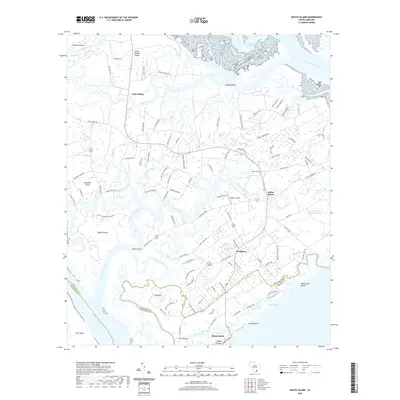
2020 Map of Edisto Island
USGS Topo · Published 2020About this map
Edisto Beach and the surrounding Sea Islands appear here as a complex network of tidal creeks and barrier landforms along the South Carolina coast. The landscape is defined by the South Edisto River and the Dawho River, which frame the low-lying terrain of Edisto Island. Significant for local history, the map shows the transition from the residential clusters at Freedman to the more dispersed agricultural legacy near Greenway Plantation Pond. Smaller settlements like Little Edisto sit near the winding Russel Creek, illustrating the island's reliance on water access. Cultural landmarks such as Trinity Cem and geographical features like The Mound provide specific points of interest for genealogists and researchers tracking family ties to the coastal parishes. The path of the Intracoastal Waterway cuts through the northern marshlands, highlighting the area's role in coastal navigation and commerce.
Find a feature on this map
113 named features on this map. Tap any name to fly to it.
Don’t see what you’re looking for? This feature index may not catch every label — zoom into the map to look around manually.
Map Details
Editions of this 2020 Edisto Island Map
This is the sole edition of this map. No revisions or reprints were ever made.
Other maps of this area

1919 · Edisto Island
USGS Topo · 1:62,500

1919 · Wadmelaw Island
USGS Topo · 1:62,500

1920 · St. Helena Sound
USGS Topo · 1:62,500

1943 · Edisto Island
USGS Topo · 1:62,500

1944 · Wadmelaw Island
USGS Topo · 1:62,500

1947 · Savannah
USGS Topo · 1:250,000

1948 · St. Helena Sound
USGS Topo · 1:62,500

1948 · Savannah
USGS Topo · 1:250,000
1956 · Edisto Beach
USGS Topo · 1:24,000
1956 · St. Helena Sound
USGS Topo · 1:24,000