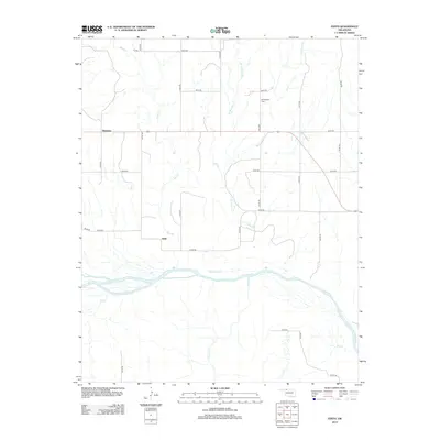
2012 Map of Edith
USGS Topo · Published 2012About this map
The Cimarron River dominates the southern landscape of this Woods County region, its braided channels creating a complex network of sandbars and seasonal watercourses. Small agricultural settlements like Plainview and Edith serve as anchors for a sprawling grid of rural section roads, illustrating the persistent land-use patterns of the Oklahoma plains. Local history is preserved at the Mt Pleasant Cem, situated north of the main east-west highway, while numerous drainage systems including Sand Cr, Buffalo Cr, and Moccasin Cr carve subtle topographic variations into the terrain. The presence of Traders Cr and Girl Cr feeding into the river highlights the importance of watershed geography in this semi-arid environment, where water access historically dictated the location of homesteads and grazing lands.
Find a feature on this map
30 named features on this map. Tap any name to fly to it.
Don’t see what you’re looking for? This feature index may not catch every label — zoom into the map to look around manually.
Map Details
Editions of this 2012 Edith Map
This is the sole edition of this map. No revisions or reprints were ever made.
Other maps of this area

1955 · Woodward
USGS Topo · 1:250,000

1958 · Woodward
USGS Topo · 1:250,000

1970 · Alabaster Caverns
USGS Topo · 1:24,000

1970 · Lookout
USGS Topo · 1:24,000

1970 · Freedom NE
USGS Topo · 1:24,000

1970 · Fairvalley
USGS Topo · 1:24,000

1970 · Freedom NW
USGS Topo · 1:24,000

1970 · Edith
USGS Topo · 1:24,000
1970 · Freedom
USGS Topo · 1:24,000

1971 · Selman SE
USGS Topo · 1:24,000