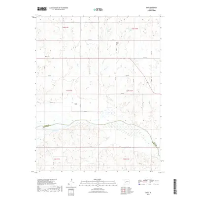
2018 Map of Edith
USGS Topo · Published 2018About this map
The Cimarron River carves a wide, braided path through this northwestern Oklahoma landscape, marking the boundary between Woods County and Woodward County. Small rural clusters such as Edith and Plainview serve as the primary points of settlement in a region defined by agricultural sections and a complex network of drainage creeks. To the north, Mount Pleasant Cemetery stands as a quiet landmark near the upper reaches of West Moccasin Creek.
Find a feature on this map
37 named features on this map. Tap any name to fly to it.
Don’t see what you’re looking for? This feature index may not catch every label — zoom into the map to look around manually.
Map Details
Editions of this 2018 Edith Map
This is the sole edition of this map. No revisions or reprints were ever made.
Other maps of this area

1955 · Woodward
USGS Topo · 1:250,000

1958 · Woodward
USGS Topo · 1:250,000

1970 · Alabaster Caverns
USGS Topo · 1:24,000

1970 · Lookout
USGS Topo · 1:24,000

1970 · Freedom NE
USGS Topo · 1:24,000

1970 · Fairvalley
USGS Topo · 1:24,000

1970 · Freedom NW
USGS Topo · 1:24,000

1970 · Edith
USGS Topo · 1:24,000
1970 · Freedom
USGS Topo · 1:24,000

1971 · Selman SE
USGS Topo · 1:24,000