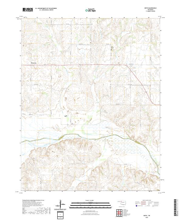
2022 Map of Edith
USGS Topo · Published 2022About this map
The Cimarron River dominates the southern landscape of this Oklahoma survey, where the river's wide, braided channel forms a natural boundary between Woods Co and Woodward Co. North of the river, the small settlements of Edith and Plainview are linked by a grid of rural section roads, including Haskell Rd and Jackson Rd. The terrain is defined by a dense network of seasonal drainages, such as Sand Creek, Moccasin Creek, and West Moccasin Creek, which carve into the plains before reaching the river valley. For those researching local history, the Mount Pleasant Cemetery stands as a significant landmark in the northern reaches of the quadrangle. The map also captures the confluence of smaller tributaries like Buffalo Creek and Traders Creek, illustrating the complex hydrology of this western Oklahoma region.
Find a feature on this map
38 named features on this map. Tap any name to fly to it.
Don’t see what you’re looking for? This feature index may not catch every label — zoom into the map to look around manually.
Map Details
Editions of this 2022 Edith Map
This is the sole edition of this map. No revisions or reprints were ever made.
Other maps of this area

1955 · Woodward
USGS Topo · 1:250,000

1958 · Woodward
USGS Topo · 1:250,000

1970 · Alabaster Caverns
USGS Topo · 1:24,000

1970 · Lookout
USGS Topo · 1:24,000

1970 · Freedom NE
USGS Topo · 1:24,000

1970 · Fairvalley
USGS Topo · 1:24,000

1970 · Freedom NW
USGS Topo · 1:24,000

1970 · Edith
USGS Topo · 1:24,000
1970 · Freedom
USGS Topo · 1:24,000

1971 · Selman SE
USGS Topo · 1:24,000