
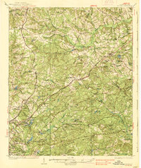
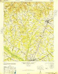
1944 Map of Edmund
USGS Topo · Published 1966About this map
The Columbia Air Base dominates the center of this wartime survey, marking a period of intense military activity just south of Columbia. To the west, the landscape is defined by the headwaters of Congaree Creek and the small rural hub of Edmund. This map provides a look at the transition from the growing urban centers of West Columbia and Cayce into the deeply wooded terrain of Lexington and Calhoun counties.
Find a feature on this map
122 named features on this map. Tap any name to fly to it.
Don’t see what you’re looking for? This feature index may not catch every label — zoom into the map to look around manually.
Map Details
Editions of this 1944 Edmund Map
This is the sole edition of this map. No revisions or reprints were ever made.
Other maps of this area

1904 · Columbia
USGS Topo · 1:125,000

1935 · Killian
USGS Topo · 1:48,000
1937 · Killian
USGS Topo · 1:62,500

1941 · Spartanburg
USGS Topo · 1:250,000

1942 · Camden
USGS Topo · 1:125,000
1944 · Gilbert
USGS Topo · 1:62,500
1944 · Seivern
USGS Topo · 1:62,500
1946 · Woodford
USGS Topo · 1:62,500
1946 · St. Matthews
USGS Topo · 1:62,500
1946 · Irmo
USGS Topo · 1:24,000