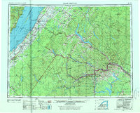
1962 Map of Edmundston
USGS Topo · Published 1976About this map
The Saint John River forms a jagged international border between Maine and New Brunswick in this early 1960s study of the North Woods. Centered on the industrial hub of Edmundston, the map reveals a landscape defined by the intersection of major waterway systems and vital rail corridors. The Canadian National Railways and Bangor and Aroostook Railroad dominate the inland transport network, connecting remote timberlands and river settlements like St-Pascal and St-Modeste.
Find a feature on this map
115 named features on this map. Tap any name to fly to it.
Don’t see what you’re looking for? This feature index may not catch every label — zoom into the map to look around manually.
Map Details
Editions of this 1962 Edmundston Map
2 editions found

Other maps of this area

1921 · Van Buren
USGS Topo · 1:250,000

1927 · Stockholm
USGS Topo · 1:48,000

1927 · Square Lake
USGS Topo · 1:48,000

1928 · Eagle Lake
USGS Topo · 1:48,000

1928 · Winterville
USGS Topo · 1:48,000

1929 · Portage
USGS Topo · 1:62,500

1929 · Caribou
USGS Topo · 1:48,000

1930 · Allagash
USGS Topo · 1:48,000

1930 · Fort Fairfield
USGS Topo · 1:48,000

1930 · St Francis
USGS Topo · 1:48,000