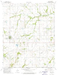
1974 Map of Edna
USGS Topo · Published 1975About this map
The Old Indian Treaty Boundary bisects this Labette County landscape, marking a significant historical line through Elm Grove and Mount Pleasant. Centered on the town of Edna, the area is defined by a traditional Midwestern agricultural grid, punctuated by vital local institutions like Elm Ch, Ellis Sch, and the Edna Cem. Transportation and utility infrastructure are prominent, including the Missouri Pacific railroad corridor and the Edna Municipal Airport.
Find a feature on this map
24 named features on this map. Tap any name to fly to it.
Don’t see what you’re looking for? This feature index may not catch every label — zoom into the map to look around manually.
Map Details
Editions of this 1974 Edna Map
This is the sole edition of this map. No revisions or reprints were ever made.
Other maps of this area

1886 · Parsons
USGS Topo · 1:125,000

1893 · Parsons
USGS Topo · 1:125,000

1901 · Vinita
USGS Topo · 1:125,000

1913 · Vinita
USGS Topo · 1:125,000

1944 · Oswego
USGS Topo · 1:62,500

1946 · Oswego
USGS Topo · 1:48,000

1946 · Mound Valley
USGS Topo · 1:62,500

1947 · Joplin
USGS Topo · 1:250,000
1948 · Oswego
USGS Topo · 1:62,500
1948 · Mound Valley
USGS Topo · 1:62,500