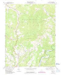
1974 Map of Edray
USGS Topo · Published 1989About this map
The Greenbrier River curves through the southeastern corner of this Pocahontas County landscape, where the valley floor meets the rising elevations of Thorny Creek Mountain and Cloverlick Mtn. Most of the terrain is protected within the Monongahela National Forest, a character defined by high peaks like Moffett Knob and Gay Knob overlooking numerous drainage basins such as Indian Draft and Warwick Run.
Find a feature on this map
48 named features on this map. Tap any name to fly to it.
Don’t see what you’re looking for? This feature index may not catch every label — zoom into the map to look around manually.
Map Details
Editions of this 1974 Edray Map
This is the sole edition of this map. No revisions or reprints were ever made.
Other maps of this area

1891 · Huntersville
USGS Topo · 1:125,000

1894 · Huntersville
USGS Topo · 1:125,000

1901 · Monterey
USGS Topo · 1:125,000

1922 · Cass
USGS Topo · 1:48,000

1923 · Marlinton
USGS Topo · 1:48,000

1923 · Warm Springs
USGS Topo · 1:48,000

1923 · Mingo
USGS Topo · 1:48,000

1924 · Cass
USGS Topo · 1:62,500

1925 · Mingo
USGS Topo · 1:62,500

1925 · Marlinton
USGS Topo · 1:62,500