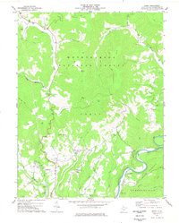
1977 Map of Edray
USGS Topo · Published 1978About this map
Monongahela National Forest dominates much of this landscape, where the high ridges of Cloverlick Mtn and Thorny Creek Mountain rise above the deep river valleys. The Greenbrier River carves through the eastern portion of the sheet, followed closely by the tracks of the Chesapeake and Ohio railroad. This corridor sustained small communities like Clawson and provided access to the timber-rich highlands. In the more settled western sections, the community of Edray serves as a hub near Wolfpen Ridge, surrounded by a network of family-centered landmarks. Local genealogy is well-preserved through numerous rural worship and burial sites, including Marys Chapel, Hannah Cem, and Mt Pleasant Ch. A prominent Fish Hatchery near Onoto highlights the area's transition towards conservation and recreation in the mid-1970s.
Find a feature on this map
53 named features on this map. Tap any name to fly to it.
Don’t see what you’re looking for? This feature index may not catch every label — zoom into the map to look around manually.
Map Details
Editions of this 1977 Edray Map
This is the sole edition of this map. No revisions or reprints were ever made.
Other maps of this area

1891 · Huntersville
USGS Topo · 1:125,000

1894 · Huntersville
USGS Topo · 1:125,000

1901 · Monterey
USGS Topo · 1:125,000

1922 · Cass
USGS Topo · 1:48,000

1923 · Marlinton
USGS Topo · 1:48,000

1923 · Warm Springs
USGS Topo · 1:48,000

1923 · Mingo
USGS Topo · 1:48,000

1924 · Cass
USGS Topo · 1:62,500

1925 · Mingo
USGS Topo · 1:62,500

1925 · Marlinton
USGS Topo · 1:62,500