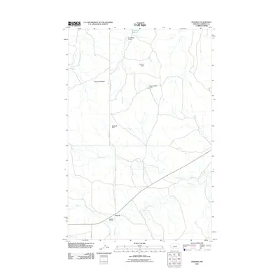
2011 Map of Edwards
USGS Topo · Published 2011About this map
Edwards serves as the primary focal point in this portion of Garfield County, situated at the junction of Edwards Rd and State Route 200. The landscape is defined by the drainage patterns of Big Dry Creek and its tributaries, including Haislett Creek and Cherry Creek. Prominent topographic features such as Adams Rocky Butte, Boslough Butte, and Elephant Butte rise above the surrounding terrain, providing distinctive landmarks for the area. Water management is evident in the northern reaches, where the Cherry Number 1 Dam and Wheatcroft Reservoir support the local environment. Steep-walled drainages like Tom Walker Coulee and Dugout Coulee cut through the earth, illustrating the erosional history of this Montana cattle country.
Find a feature on this map
13 named features on this map. Tap any name to fly to it.
Don’t see what you’re looking for? This feature index may not catch every label — zoom into the map to look around manually.
Map Details
Editions of this 2011 Edwards Map
This is the sole edition of this map. No revisions or reprints were ever made.
Other maps of this area

1954 · Jordan
USGS Topo · 1:250,000

1956 · Jordan
USGS Topo · 1:250,000

1958 · Jordan
USGS Topo · 1:250,000

1964 · Jordan
USGS Topo · 1:250,000

1965 · Robertson School
USGS Topo · 1:24,000

1965 · Big Dry School
USGS Topo · 1:24,000

1965 · Edwards
USGS Topo · 1:24,000
1965 · Sand Springs
USGS Topo · 1:24,000
1965 · Twin Buttes
USGS Topo · 1:24,000
1965 · Van Dusen Spring
USGS Topo · 1:24,000