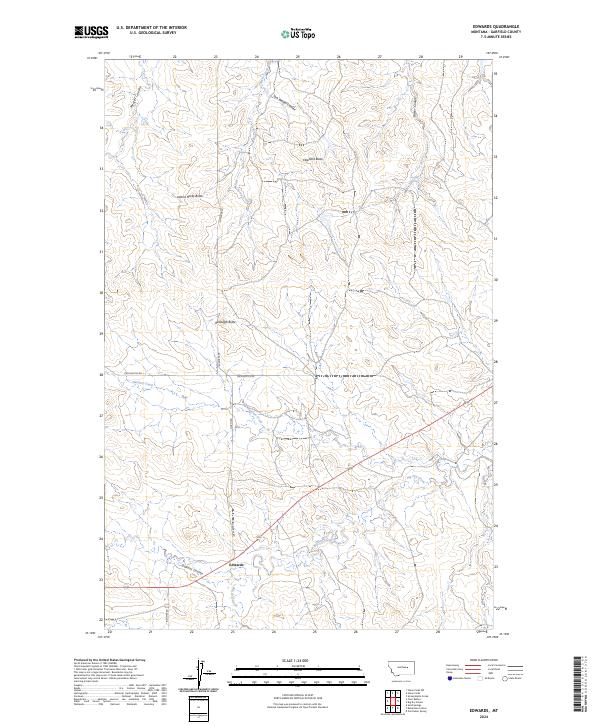
2024 Map of Edwards
USGS Topo · Published 2024About this map
Edwards stands as the primary namesake settlement in this Garfield County landscape, positioned along the banks of Big Dry Creek and Dugout Coulee. The topography is defined by prominent high points such as Elephant Butte, Adams Rocky Butte, and Boslough Butte, which serve as natural landmarks across the plains. These features reflect the erosion patterns typical of the region, where numerous coulees and creeks like Meckel Coulee and Haislett Creek carve through the terrain.
Find a feature on this map
19 named features on this map. Tap any name to fly to it.
Don’t see what you’re looking for? This feature index may not catch every label — zoom into the map to look around manually.
Map Details
Editions of this 2024 Edwards Map
This is the sole edition of this map. No revisions or reprints were ever made.
Other maps of this area

1954 · Jordan
USGS Topo · 1:250,000

1956 · Jordan
USGS Topo · 1:250,000

1958 · Jordan
USGS Topo · 1:250,000

1964 · Jordan
USGS Topo · 1:250,000

1965 · Robertson School
USGS Topo · 1:24,000

1965 · Big Dry School
USGS Topo · 1:24,000

1965 · Edwards
USGS Topo · 1:24,000
1965 · Sand Springs
USGS Topo · 1:24,000
1965 · Twin Buttes
USGS Topo · 1:24,000
1965 · Van Dusen Spring
USGS Topo · 1:24,000