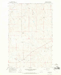
1965 Map of Edwards
USGS Topo · Published 1968About this map
Big Dry Creek defines the lower drainage of this Garfield County landscape, where the prairie is broken by prominent rises and coulees. During this mid-1960s survey, the area was characterized by sparse settlement and remote homesteads, with Edwards and Haislett serving as the primary named points of interest. The terrain is marked by distinct geological formations, including Elephant Butte, Adams Rocky Butte, and Boslough Butte, which dominate the central and northern sections of the quadrangle.
Find a feature on this map
17 named features on this map. Tap any name to fly to it.
Don’t see what you’re looking for? This feature index may not catch every label — zoom into the map to look around manually.
Map Details
Editions of this 1965 Edwards Map
This is the sole edition of this map. No revisions or reprints were ever made.
Other maps of this area
1954 · Jordan
USGS Topo · 1:250,000
1956 · Jordan
USGS Topo · 1:250,000
1958 · Jordan
USGS Topo · 1:250,000
1964 · Jordan
USGS Topo · 1:250,000
1965 · Robertson School
USGS Topo · 1:24,000
1965 · Big Dry School
USGS Topo · 1:24,000
1965 · Sand Springs
USGS Topo · 1:24,000
1965 · Twin Buttes
USGS Topo · 1:24,000
1965 · Van Dusen Spring
USGS Topo · 1:24,000
1983 · Steve Forks
USGS Topo · 1:24,000