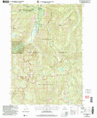
2004 Map of Edwardsburg
USGS Topo · Published 2007About this map
Edwardsburg sits at the northern edge of this high-elevation terrain, where the early 21st-century landscape is defined by the intersection of forest management and protected wilderness. Located near the confluence of Big Creek and Logan Creek, this small settlement provides a rare point of human activity within the vast Payette National Forest. The geography here transitions abruptly from the managed forest into the Frank Church-River of No Return Wilderness, marked by a distinct Wilderness Boundary that separates road-accessible areas from the interior backcountry.
Find a feature on this map
29 named features on this map. Tap any name to fly to it.
Don’t see what you’re looking for? This feature index may not catch every label — zoom into the map to look around manually.
Map Details
Editions of this 2004 Edwardsburg Map
This is the sole edition of this map. No revisions or reprints were ever made.
Other maps of this area

1937 · Yellow Pine
USGS Topo · 1:48,000

1937 · Big Creek
USGS Topo · 1:48,000

1942 · Big Creek
USGS Topo · 1:62,500

1943 · Yellow Pine
USGS Topo · 1:62,500

1956 · Elk City
USGS Topo · 1:250,000

1957 · Challis
USGS Topo · 1:250,000

1960 · Elk City
USGS Topo · 1:250,000

1960 · Challis
USGS Topo · 1:250,000

1963 · Challis
USGS Topo · 1:250,000

1969 · Edwardsburg
USGS Topo · 1:24,000