
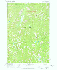
1969 Map of Edwardsburg
USGS Topo · Published 1971About this map
Edwardsburg and the nearby Logan settlement sit at the heart of this high-elevation wilderness within the Payette National Forest. This 1960s survey documents a landscape defined by mining activity and remote drainages, centered around the Sunday Mine north of Logan Mountain. The terrain is characterized by steep, glacially-carved basins and sharp divides like Missouri Ridge and The Pinnacles. High mountain water sources are abundant, including Logan Lake, Lick Lake, and Bear Lake, which feed into major drainages like Big Creek and Monumental Creek. Navigation through this backcountry relied on a network of routes such as the Pack Trail that winds through Cougar Basin, illustrating the isolated nature of mining and Forest Service operations in the central Idaho mountains during this era.
Find a feature on this map
27 named features on this map. Tap any name to fly to it.
Don’t see what you’re looking for? This feature index may not catch every label — zoom into the map to look around manually.
Map Details
Editions of this 1969 Edwardsburg Map
2 editions found
Other maps of this area

1937 · Yellow Pine
USGS Topo · 1:48,000

1937 · Big Creek
USGS Topo · 1:48,000

1942 · Big Creek
USGS Topo · 1:62,500

1943 · Yellow Pine
USGS Topo · 1:62,500

1956 · Elk City
USGS Topo · 1:250,000

1957 · Challis
USGS Topo · 1:250,000

1960 · Elk City
USGS Topo · 1:250,000

1960 · Challis
USGS Topo · 1:250,000

1963 · Challis
USGS Topo · 1:250,000

1969 · Profile Gap
USGS Topo · 1:24,000