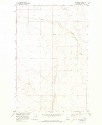
1970 Map of Een School
USGS Topo · Published 1973About this map
East Fork Black Coulee carves a winding path through this portion of Hill County, Montana, defining the local drainage patterns as they existed in the early 1970s. This survey, conducted as part of the Department of the Interior's Missouri River Basin development program, shows a sparsely settled agricultural landscape dominated by section lines and natural coulees. Local educational history is represented by the isolated Een School, while the presence of the Rudyard Gun Club points to the area's established recreational character. The map meticulously records the transition between Township 30, 31, and 32 North, capturing a period when land use remained primarily focused on large-scale ranching and farming prior to any significant modern infrastructure expansion.
Find a feature on this map
5 named features on this map. Tap any name to fly to it.
Don’t see what you’re looking for? This feature index may not catch every label — zoom into the map to look around manually.
Map Details
Editions of this 1970 Een School Map
This is the sole edition of this map. No revisions or reprints were ever made.
Other maps of this area

1919 · Big Sandy
USGS Topo · 1:125,000

1919 · Alma
USGS Topo · 1:125,000

1920 · Gildford
USGS Topo · 1:125,000

1943 · Gildford
USGS Topo · 1:125,000

1954 · Shelby
USGS Topo · 1:250,000

1958 · Shelby
USGS Topo · 1:250,000

1969 · Fourteenmile Coulee SW
USGS Topo · 1:24,000

1969 · Hingham
USGS Topo · 1:24,000

1969 · Fourteenmile Coulee NW
USGS Topo · 1:24,000
1970 · Rocky Coulee SE
USGS Topo · 1:24,000