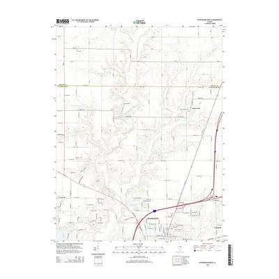
2015 Map of Effingham North
USGS Topo · Published 2015About this map
Effingham anchors the southern portion of this landscape, serving as a hub where the mid-century interstate development intersects with the older grid of the Illinois prairie. The topography is defined by the Little Wabash River and its numerous tributaries, including Hog Cr, Rattlesnake Cr, and Green Cr, which carve through the till plain. For those tracing local heritage, the map identifies several rural burying grounds such as Mound Cem, Ramsey Cem, and Rentfrow Cem, often situated on higher ground overlooking the creek valleys. To the east, the village of Teutopolis and the Saint Anthony Catholic Cem reflect the distinct settlement patterns of the region. The map also captures the recreational and water-management importance of Lake Pauline and the edge of Lake Sara, illustrating how water resources were developed as the city expanded northward.
Find a feature on this map
63 named features on this map. Tap any name to fly to it.
Don’t see what you’re looking for? This feature index may not catch every label — zoom into the map to look around manually.
Map Details
Editions of this 2015 Effingham North Map
This is the sole edition of this map. No revisions or reprints were ever made.
Other maps of this area

1934 · Mattoon
USGS Topo · 1:62,500

1937 · Mattoon
USGS Topo · 1:62,500

1947 · Stewardson
USGS Topo · 1:62,500

1949 · Stewardson
USGS Topo · 1:62,500

1950 · Effingham
USGS Topo · 1:62,500

1951 · Effingham
USGS Topo · 1:62,500

1953 · Teutopolis
USGS Topo · 1:62,500

1958 · Decatur
USGS Topo · 1:250,000

1961 · Decatur
USGS Topo · 1:250,000
1981 · Stewardson East
USGS Topo · 1:24,000