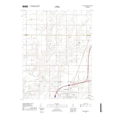
2018 Map of Effingham North
USGS Topo · Published 2018About this map
Effingham serves as the focal point of this Illinois survey, positioned at the convergence of major transit corridors and the upper reaches of the Little Wabash River. The city's northward expansion is marked by residential developments like Shenandoah Ave and E Cadillac Dr, while the surrounding countryside maintains its agricultural character across the Shelby Co and Effingham Co line. Significant water features including Lake Sara and Lake Pauline define the southwestern and central portions of the landscape, providing local landmarks for both recreation and geography. Genealogists will find a high density of preserved burial sites throughout the townships, from the Effingham City Cem and Saint Anthony Catholic Cem near the city center to the rural Mound Cem, Ramsey Cem, and Rentfrow Cem. The map also documents smaller outlying communities such as Green Creek and Sigel, situated amidst a network of creeks including Hog Cr, Rattlesnake Cr, and Sugar Fork.
Find a feature on this map
76 named features on this map. Tap any name to fly to it.
Don’t see what you’re looking for? This feature index may not catch every label — zoom into the map to look around manually.
Map Details
Editions of this 2018 Effingham North Map
This is the sole edition of this map. No revisions or reprints were ever made.
Other maps of this area

1934 · Mattoon
USGS Topo · 1:62,500

1937 · Mattoon
USGS Topo · 1:62,500

1947 · Stewardson
USGS Topo · 1:62,500

1949 · Stewardson
USGS Topo · 1:62,500

1950 · Effingham
USGS Topo · 1:62,500

1951 · Effingham
USGS Topo · 1:62,500

1953 · Teutopolis
USGS Topo · 1:62,500

1958 · Decatur
USGS Topo · 1:250,000

1961 · Decatur
USGS Topo · 1:250,000
1981 · Stewardson East
USGS Topo · 1:24,000