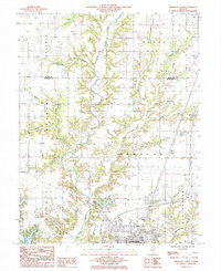
1985 Map of Effingham North
USGS Topo · Published 1985About this map
The Little Wabash River and its numerous tributaries, including Rattlesnake Creek and Shoal Creek, carve a complex drainage pattern through the glacial till of this central Illinois landscape. This mid-1980s record captures the northern periphery of Effingham as it expanded into the surrounding rural townships. The map reflects a blend of traditional agricultural land use and mid-century leisure developments, evidenced by the presence of Lake Sara and Lake Pauline.
Find a feature on this map
29 named features on this map. Tap any name to fly to it.
Don’t see what you’re looking for? This feature index may not catch every label — zoom into the map to look around manually.
Map Details
Editions of this 1985 Effingham North Map
This is the sole edition of this map. No revisions or reprints were ever made.
Other maps of this area

1934 · Mattoon
USGS Topo · 1:62,500

1937 · Mattoon
USGS Topo · 1:62,500

1947 · Stewardson
USGS Topo · 1:62,500

1949 · Stewardson
USGS Topo · 1:62,500

1950 · Effingham
USGS Topo · 1:62,500

1951 · Effingham
USGS Topo · 1:62,500

1953 · Teutopolis
USGS Topo · 1:62,500

1958 · Decatur
USGS Topo · 1:250,000

1961 · Decatur
USGS Topo · 1:250,000
1981 · Stewardson East
USGS Topo · 1:24,000