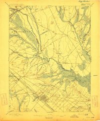
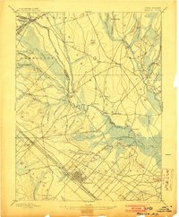
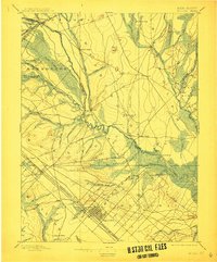
1898 Map of Egg Harbor
USGS Topo · Published 1912About this map
The Mullica River defines this late 19th-century landscape, carving a path through the Pine Barrens of Atlantic and Burlington Counties. The river acts as a central artery for several established settlements, including the industrial and historic sites of Batsto and Pleasant Mills, where water power was critical to early regional development. The map reveals an intricate network of waterways like Nescochaque Creek and the Wading River or East Branch of Mullica R., which fed into the larger estuary system before reaching the coast. Transportation is dominated by the heavy presence of the Pennsylvania Railroad and the Atlantic City R.R. (Atlantic City Division), both of which intersect at Egg Harbor, anchoring the town as a primary rail hub. Beyond the tracks, the terrain gives way to the expansive Great Swamp and numerous cranberry bogs like Friendship Bogs, illustrating the land's transition from managed timber and iron resources to agriculture.
Find a feature on this map
72 named features on this map. Tap any name to fly to it.
Don’t see what you’re looking for? This feature index may not catch every label — zoom into the map to look around manually.
Map Details
Editions of this 1898 Egg Harbor Map
4 editions found

Other maps of this area

1884 · Whitings
USGS Topo · 1:62,500

1887 · Atlantic City
USGS Topo · 1:62,500

1888 · Pemberton
USGS Topo · 1:62,500

1888 · Little Egg Harbor
USGS Topo · 1:62,500

1888 · Mount Holly
USGS Topo · 1:62,500

1888 · Whitings
USGS Topo · 1:62,500

1890 · Great Egg Harbor
USGS Topo · 1:62,500

1890 · Hammonton
USGS Topo · 1:62,500

1890 · Tuckahoe
USGS Topo · 1:62,500

1890 · Mullica
USGS Topo · 1:62,500