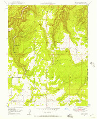
1949 Map of Egnar
USGS Topo · Published 1957About this map
Uranium and vanadium mining activity characterizes this 1949 survey of the San Miguel and Dolores county line, a project conducted in cooperation with the United States Atomic Energy Commission. The settlement of Egnar serves as the local hub, supported by the Egnar School and the nearby Monticello Road. The landscape is heavily marked by small-scale mineral extraction, including the Legin Mines, Frankie Mine, Hawk Mine, and Golden Rod Mines. These operations are interspersed among the deep incisions of Bishop Canyon and Bush Canyon. High-altitude agriculture is evidenced by the curiously named The Spud Patch, while water security for livestock and miners in this arid environment relied on developed sources like Overall Spring, Strawberry Spring, and a lone Windmill. The eastern edge of the quadrangle transitions into the protected timberlands of the Uncompahgre National Forest.
Find a feature on this map
29 named features on this map. Tap any name to fly to it.
Don’t see what you’re looking for? This feature index may not catch every label — zoom into the map to look around manually.
Map Details
Editions of this 1949 Egnar Map
4 editions found
Other maps of this area

1885 · La Sal
USGS Topo · 1:250,000

1886 · Abajo
USGS Topo · 1:250,000

1892 · Abajo
USGS Topo · 1:250,000

1893 · Abajo
USGS Topo · 1:250,000

1916 · Paradox Valley
USGS Topo · 1:125,000

1922 · Paradox Valley
USGS Topo · 1:125,000

1948 · Horse Range Mesa
USGS Topo · 1:24,000

1948 · Hamm Canyon
USGS Topo · 1:24,000

1949 · Egnar
USGS Topo · 1:24,000

1949 · Joe Davis Hill
USGS Topo · 1:24,000